Prefecture List >
All Prefecture >
箕土路遺跡
箕土路遺跡
| URL | https://sitereports.nabunken.go.jp/90670 | ||||||||||||||||||||||||||||||||||||||||||||
|---|---|---|---|---|---|---|---|---|---|---|---|---|---|---|---|---|---|---|---|---|---|---|---|---|---|---|---|---|---|---|---|---|---|---|---|---|---|---|---|---|---|---|---|---|---|
| DOI 2D code |
2D Code download
※二次元コードが有効化するまでにPDFの登録から2週間程度かかる場合があります。
|
||||||||||||||||||||||||||||||||||||||||||||
| DOI | http://doi.org/10.24484/sitereports.90670 | ||||||||||||||||||||||||||||||||||||||||||||
| For Citation | 財団法人大阪府埋蔵文化財協会 1987 『財団法人大阪府埋蔵文化財協会調査報告書13:箕土路遺跡』財団法人大阪府埋蔵文化財協会 | ||||||||||||||||||||||||||||||||||||||||||||
| 財団法人大阪府埋蔵文化財協会 1987 『箕土路遺跡』財団法人大阪府埋蔵文化財協会調査報告書13 | |||||||||||||||||||||||||||||||||||||||||||||
|
wikipedia 出典テンプレート :
{{Cite book ... 開く
|
|||||||||||||||||||||||||||||||||||||||||||||
| File |
※モバイル対応のPDFは解像度を下げているため、画像が粗く文章が読みにくい場合があります。
|
||||||||||||||||||||||||||||||||||||||||||||
| Title | 箕土路遺跡 | ||||||||||||||||||||||||||||||||||||||||||||
| Participation-organizations |
 大阪府文化財センター
- 大阪府 大阪府文化財センター
- 大阪府
|
||||||||||||||||||||||||||||||||||||||||||||
| Store Page | https://www.occh.or.jp/?s=book ※ 有償頒布・配布していない場合もあります |
||||||||||||||||||||||||||||||||||||||||||||
| Alternative | みどろいせき | ||||||||||||||||||||||||||||||||||||||||||||
| Subtitle | 都市計画道路磯之上山直線建設に伴う発掘調査報告書 | ||||||||||||||||||||||||||||||||||||||||||||
| Volume | |||||||||||||||||||||||||||||||||||||||||||||
| Series | 財団法人大阪府埋蔵文化財協会調査報告書 | ||||||||||||||||||||||||||||||||||||||||||||
| Series Number | 13 | ||||||||||||||||||||||||||||||||||||||||||||
| Author | |||||||||||||||||||||||||||||||||||||||||||||
| Editorial Organization |
財団法人大阪府埋蔵文化財協会
|
||||||||||||||||||||||||||||||||||||||||||||
| Publisher |
財団法人大阪府埋蔵文化財協会
|
||||||||||||||||||||||||||||||||||||||||||||
| Publish Date | 19870331 | ||||||||||||||||||||||||||||||||||||||||||||
| Publisher ID | |||||||||||||||||||||||||||||||||||||||||||||
| ZIP CODE | 540 | ||||||||||||||||||||||||||||||||||||||||||||
| TEL | 069423885 | ||||||||||||||||||||||||||||||||||||||||||||
| Aaddress | 大阪市東区谷町2丁目36番地 大手前ウサミビル | ||||||||||||||||||||||||||||||||||||||||||||
| Report Type Codes |
埋蔵文化財(遺跡等)-発掘調査・分布調査・資料調査等
|
||||||||||||||||||||||||||||||||||||||||||||
| NII Type | Research Paper | ||||||||||||||||||||||||||||||||||||||||||||
| Research Report | 掲載されている(発掘調査報告書総目録の掲載対象) | ||||||||||||||||||||||||||||||||||||||||||||
| NCID | |||||||||||||||||||||||||||||||||||||||||||||
| JP Number | |||||||||||||||||||||||||||||||||||||||||||||
| Other Resource |
|
||||||||||||||||||||||||||||||||||||||||||||
| Remark | |||||||||||||||||||||||||||||||||||||||||||||
| Articles | |||||||||||||||||||||||||||||||||||||||||||||
| Site |
|
||||||||||||||||||||||||||||||||||||||||||||
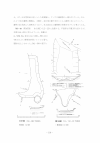
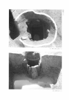
| Abstract | 調査地の南東部、西大路遺跡に近接するところで、弥生時代後期から古墳時代前期の包含層を確認した。しかしその後平安時代後期までは、顕著な営みを確認することが出来なかった。鎌倉時代から江戸時代にかけては、時期不詳の掘立柱建物数棟を検出したほか、21基の井戸が、井筒に曲物を用いたものから、徐々に石組み井側へと変化することを確認した。 | ||||||||||||||||||||||||||||||||||||||||||||