府中遺跡
| URL | https://sitereports.nabunken.go.jp/18406 | ||||||||||||||||||||||||||||||||||||||||||||
|---|---|---|---|---|---|---|---|---|---|---|---|---|---|---|---|---|---|---|---|---|---|---|---|---|---|---|---|---|---|---|---|---|---|---|---|---|---|---|---|---|---|---|---|---|---|
| DOI 二次元コード |
二次元コードダウンロード
※二次元コードが有効化するまでにPDFの登録から2週間程度かかる場合があります。
|
||||||||||||||||||||||||||||||||||||||||||||
| DOI | http://doi.org/10.24484/sitereports.18406 | ||||||||||||||||||||||||||||||||||||||||||||
| 引用表記 | 大阪府教育委員会文化財保護課 2010 『大阪府埋蔵文化財調査報告2010-5:府中遺跡』大阪府教育委員会 | ||||||||||||||||||||||||||||||||||||||||||||
| 大阪府教育委員会文化財保護課 2010 『府中遺跡』大阪府埋蔵文化財調査報告2010-5 | |||||||||||||||||||||||||||||||||||||||||||||
|
wikipedia 出典テンプレート :
{{Cite book ... 開く
|
|||||||||||||||||||||||||||||||||||||||||||||
| ファイル |
※モバイル対応のPDFは解像度を下げているため、画像が粗く文章が読みにくい場合があります。
|
||||||||||||||||||||||||||||||||||||||||||||
| 書名 | 府中遺跡 | ||||||||||||||||||||||||||||||||||||||||||||
| 発行(管理)機関 | 大阪府教育庁 - 大阪府 | ||||||||||||||||||||||||||||||||||||||||||||
| 書名かな | ふちゅういせき | ||||||||||||||||||||||||||||||||||||||||||||
| 副書名 | 都市計画道路和泉中央線整備事業に伴う発掘調査 | ||||||||||||||||||||||||||||||||||||||||||||
| 巻次 | |||||||||||||||||||||||||||||||||||||||||||||
| シリーズ名 | 大阪府埋蔵文化財調査報告 | ||||||||||||||||||||||||||||||||||||||||||||
| シリーズ番号 | 2010-5 | ||||||||||||||||||||||||||||||||||||||||||||
| 編著者名 | |||||||||||||||||||||||||||||||||||||||||||||
| 編集機関 |
大阪府教育委員会文化財保護課
|
||||||||||||||||||||||||||||||||||||||||||||
| 発行機関 |
大阪府教育委員会
|
||||||||||||||||||||||||||||||||||||||||||||
| 発行年月日 | 20101029 | ||||||||||||||||||||||||||||||||||||||||||||
| 作成機関ID | 27000 | ||||||||||||||||||||||||||||||||||||||||||||
| 郵便番号 | 5408571 | ||||||||||||||||||||||||||||||||||||||||||||
| 電話番号 | 0669410351 | ||||||||||||||||||||||||||||||||||||||||||||
| 住所 | 大阪府大阪市中央区大手前2丁目 | ||||||||||||||||||||||||||||||||||||||||||||
| 報告書種別 |
埋蔵文化財(遺跡等)-発掘調査・分布調査・資料調査等
|
||||||||||||||||||||||||||||||||||||||||||||
| 資料タイプ | Research Paper | ||||||||||||||||||||||||||||||||||||||||||||
| 発掘調査報告 | 掲載されている(発掘調査報告書総目録の掲載対象) | ||||||||||||||||||||||||||||||||||||||||||||
| 所蔵大学(NCID) | |||||||||||||||||||||||||||||||||||||||||||||
| JP番号 | |||||||||||||||||||||||||||||||||||||||||||||
| 他の電子リソース |
|
||||||||||||||||||||||||||||||||||||||||||||
| 備考 | |||||||||||||||||||||||||||||||||||||||||||||
| 所収論文 | |||||||||||||||||||||||||||||||||||||||||||||
| 所収遺跡 |
|
||||||||||||||||||||||||||||||||||||||||||||
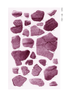
| 要約 | 平成14年度から平成17年度までは道路の拡幅用地で延長約250m、幅約10m、平成18年度は立体交差工事用地で、延べ面積約3335㎡を調査した。 縄文時代で中末期の土器集積遺構や炭集積遺構、焼土、縄文時代後期・晩期の土坑を検出した。弥生時代では前期頃の河道や中期の方形周溝墓を5基検出し、周溝から多数の供献土器が出土した。弥生時代後期から古墳時代では溝や土坑を検出した。 |
||||||||||||||||||||||||||||||||||||||||||||