Prefecture List >
All Prefecture >
水込遺跡
水込遺跡
| URL | https://sitereports.nabunken.go.jp/90855 | ||||||||||||||||||||||||||||||||||||||||||||
|---|---|---|---|---|---|---|---|---|---|---|---|---|---|---|---|---|---|---|---|---|---|---|---|---|---|---|---|---|---|---|---|---|---|---|---|---|---|---|---|---|---|---|---|---|---|
| DOI 2D code |
2D Code download
※二次元コードが有効化するまでにPDFの登録から2週間程度かかる場合があります。
|
||||||||||||||||||||||||||||||||||||||||||||
| DOI | http://doi.org/10.24484/sitereports.90855 | ||||||||||||||||||||||||||||||||||||||||||||
| For Citation | 財団法人大阪府埋蔵文化財協会 1990 『財団法人大阪府埋蔵文化財協会調査報告書58:水込遺跡』財団法人大阪府埋蔵文化財協会 | ||||||||||||||||||||||||||||||||||||||||||||
| 財団法人大阪府埋蔵文化財協会 1990 『水込遺跡』財団法人大阪府埋蔵文化財協会調査報告書58 | |||||||||||||||||||||||||||||||||||||||||||||
|
wikipedia 出典テンプレート :
{{Cite book ... 開く
|
|||||||||||||||||||||||||||||||||||||||||||||
| File |
※モバイル対応のPDFは解像度を下げているため、画像が粗く文章が読みにくい場合があります。
|
||||||||||||||||||||||||||||||||||||||||||||
| Title | 水込遺跡 | ||||||||||||||||||||||||||||||||||||||||||||
| Participation-organizations |
 大阪府文化財センター
- 大阪府 大阪府文化財センター
- 大阪府
|
||||||||||||||||||||||||||||||||||||||||||||
| Store Page | https://www.occh.or.jp/?s=book ※ 有償頒布・配布していない場合もあります |
||||||||||||||||||||||||||||||||||||||||||||
| Alternative | みずこしいせき | ||||||||||||||||||||||||||||||||||||||||||||
| Subtitle | 主要地方道岸和田・牛滝山・貝塚線建設に伴う発掘調査報告書 | ||||||||||||||||||||||||||||||||||||||||||||
| Volume | |||||||||||||||||||||||||||||||||||||||||||||
| Series | 財団法人大阪府埋蔵文化財協会調査報告書 | ||||||||||||||||||||||||||||||||||||||||||||
| Series Number | 58 | ||||||||||||||||||||||||||||||||||||||||||||
| Author | |||||||||||||||||||||||||||||||||||||||||||||
| Editorial Organization |
財団法人大阪府埋蔵文化財協会
|
||||||||||||||||||||||||||||||||||||||||||||
| Publisher |
財団法人大阪府埋蔵文化財協会
|
||||||||||||||||||||||||||||||||||||||||||||
| Publish Date | 19900331 | ||||||||||||||||||||||||||||||||||||||||||||
| Publisher ID | |||||||||||||||||||||||||||||||||||||||||||||
| ZIP CODE | 540 | ||||||||||||||||||||||||||||||||||||||||||||
| TEL | 069423885 | ||||||||||||||||||||||||||||||||||||||||||||
| Aaddress | 大阪市東区谷町2丁目2番20号 大手前ウサミビル | ||||||||||||||||||||||||||||||||||||||||||||
| Report Type Codes |
埋蔵文化財(遺跡等)-発掘調査・分布調査・資料調査等
|
||||||||||||||||||||||||||||||||||||||||||||
| NII Type | Research Paper | ||||||||||||||||||||||||||||||||||||||||||||
| Research Report | 掲載されている(発掘調査報告書総目録の掲載対象) | ||||||||||||||||||||||||||||||||||||||||||||
| NCID | |||||||||||||||||||||||||||||||||||||||||||||
| JP Number | |||||||||||||||||||||||||||||||||||||||||||||
| Other Resource |
|
||||||||||||||||||||||||||||||||||||||||||||
| Remark | |||||||||||||||||||||||||||||||||||||||||||||
| Articles | |||||||||||||||||||||||||||||||||||||||||||||
| Site |
|
||||||||||||||||||||||||||||||||||||||||||||
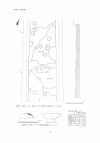
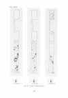
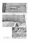
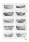
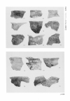
| Abstract | 府道建設に伴い調査を実施した。当遺跡は二俣池北遺跡の南側に続く遺跡で、掘立柱建物34棟をはじめ、土坑、溝などを検出した。これらは、7世紀代から12世紀代までをⅦ期の変遷に分けることが可能で、その中心と考えられるのは、4棟の建物の棟方向がほぼ正方位に近い7世紀前半から中葉にかけてである。検出した建物は、2間×3間もしくは3間×4間の規模である。 |
||||||||||||||||||||||||||||||||||||||||||||