山之脇遺跡第3次発掘調査報告書
| URL | https://sitereports.nabunken.go.jp/129311 | ||||||||||||||||||||||||||||||||||||||||||||||||||||||
|---|---|---|---|---|---|---|---|---|---|---|---|---|---|---|---|---|---|---|---|---|---|---|---|---|---|---|---|---|---|---|---|---|---|---|---|---|---|---|---|---|---|---|---|---|---|---|---|---|---|---|---|---|---|---|---|
| DOI 2D code |
2D Code download
※二次元コードが有効化するまでにPDFの登録から2週間程度かかる場合があります。
|
||||||||||||||||||||||||||||||||||||||||||||||||||||||
| DOI | http://doi.org/10.24484/sitereports.129311 | ||||||||||||||||||||||||||||||||||||||||||||||||||||||
| For Citation | 彦根市歴史まちづくり部文化財課 2021 『彦根市埋蔵文化財調査報告書85:山之脇遺跡第3次発掘調査報告書』彦根市歴史まちづくり部文化財課 | ||||||||||||||||||||||||||||||||||||||||||||||||||||||
| 彦根市歴史まちづくり部文化財課 2021 『山之脇遺跡第3次発掘調査報告書』彦根市埋蔵文化財調査報告書85 | |||||||||||||||||||||||||||||||||||||||||||||||||||||||
|
wikipedia 出典テンプレート :
{{Cite book ... 開く
|
|||||||||||||||||||||||||||||||||||||||||||||||||||||||
| File |
※モバイル対応のPDFは解像度を下げているため、画像が粗く文章が読みにくい場合があります。
|
||||||||||||||||||||||||||||||||||||||||||||||||||||||
| Title | 山之脇遺跡第3次発掘調査報告書 | ||||||||||||||||||||||||||||||||||||||||||||||||||||||
| Participation-organizations | 彦根市 - 滋賀県 | ||||||||||||||||||||||||||||||||||||||||||||||||||||||
| Store Page | https://www.city.hikone.lg.jp/kanko/rekishi/9/3/index.html ※ 有償頒布・配布していない場合もあります |
||||||||||||||||||||||||||||||||||||||||||||||||||||||
| Alternative | やまのわきいせきだいさんじはっくつちょうさほうこくしょ | ||||||||||||||||||||||||||||||||||||||||||||||||||||||
| Subtitle | 宅地造成に伴う発掘調査 | ||||||||||||||||||||||||||||||||||||||||||||||||||||||
| Volume | |||||||||||||||||||||||||||||||||||||||||||||||||||||||
| Series | 彦根市埋蔵文化財調査報告書 | ||||||||||||||||||||||||||||||||||||||||||||||||||||||
| Series Number | 85 | ||||||||||||||||||||||||||||||||||||||||||||||||||||||
| Author | |||||||||||||||||||||||||||||||||||||||||||||||||||||||
| Editorial Organization |
彦根市歴史まちづくり部文化財課
|
||||||||||||||||||||||||||||||||||||||||||||||||||||||
| Publisher |
彦根市歴史まちづくり部文化財課
|
||||||||||||||||||||||||||||||||||||||||||||||||||||||
| Publish Date | 20210331 | ||||||||||||||||||||||||||||||||||||||||||||||||||||||
| Publisher ID | 25202 | ||||||||||||||||||||||||||||||||||||||||||||||||||||||
| ZIP CODE | 5220001 | ||||||||||||||||||||||||||||||||||||||||||||||||||||||
| TEL | 0749265833 | ||||||||||||||||||||||||||||||||||||||||||||||||||||||
| Aaddress | 滋賀県彦根市尾末町1番38号 | ||||||||||||||||||||||||||||||||||||||||||||||||||||||
| Report Type Codes |
埋蔵文化財(遺跡等)-発掘調査・分布調査・資料調査等
|
||||||||||||||||||||||||||||||||||||||||||||||||||||||
| NII Type | Research Paper | ||||||||||||||||||||||||||||||||||||||||||||||||||||||
| Research Report | 掲載されている(発掘調査報告書総目録の掲載対象) | ||||||||||||||||||||||||||||||||||||||||||||||||||||||
| NCID | |||||||||||||||||||||||||||||||||||||||||||||||||||||||
| JP Number | |||||||||||||||||||||||||||||||||||||||||||||||||||||||
| Other Resource |
|
||||||||||||||||||||||||||||||||||||||||||||||||||||||
| Remark | |||||||||||||||||||||||||||||||||||||||||||||||||||||||
| Articles | |||||||||||||||||||||||||||||||||||||||||||||||||||||||
| Site |
|
||||||||||||||||||||||||||||||||||||||||||||||||||||||
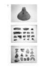
| Abstract | 彦根市北部、雨壺山南麓に位置する弥生時代終末~古墳時代初頭にかけての時期の集落跡。また、中世後期の耕作地。弥生時代終末~古墳時代初頭頃の竪穴建物と中世後期の耕作痕跡などを検出した。 | ||||||||||||||||||||||||||||||||||||||||||||||||||||||